Rural 5G in Hong Kong: From Site Selection to Useful Coverage
A review of nine rural 5G locations, examining existing infrastructure, antenna placement, and field observations alongside revised propagation simulations from Tai Tam.

When evaluating a proposed mobile base station, the core question is straightforward: how much useful coverage will it actually deliver to the people living, commuting, or hiking nearby?
A building can be convenient to acquire and equip, yet completely misaligned with the surrounding topography. A hilltop mast offers broad line of sight, but risks overshooting valleys or causing co-channel interference. Even an ideally situated site will underperform if its antenna azimuths face away from target corridors. Those engineering trade-offs matter far more than ticking boxes on a deployment list.
Hong Kong’s Subsidy Scheme to Extend 5G Coverage in Rural and Remote Areas, launched in July 2025, offers a timely opportunity to examine these design choices. Administered by OFCA, the programme targets roughly 50 rural locations. Its FAQ outlines specific expectations for service quality, terrain assessments, and multi-operator infrastructure sharing. The practical engineering challenge lies in translating those policy objectives into reliable signal on the ground.
This article expands upon my 3 January 2026 HKEPC analysis, incorporating follow-up field observations through 19 August. The network observations primarily track csl. Programme documentation was verified on 9 September 2026; specific site visits, imagery, and field logs retain their original recorded dates. Ongoing construction may have altered local conditions since publication.
What I look for in a site
I evaluate a site by starting at the target coverage areas and looking back toward the proposed antenna locations. Ridges, dense canopies, building clusters, and steep elevation drops can easily obstruct line of sight. Elevation is an asset only if the antenna tilt can cleanly project RF energy into the intended zone. Practical constraints matter just as much: an optimal radio location is useless without accessible optical backhaul and sufficient electrical service.
A sector directs RF energy across a specific geographic arc from a base station. Its horizontal bearing (azimuth) and vertical tilt govern the footprint. Multiple sectors allow a single mast to serve distinct areas at varying distances and elevations. An active antenna unit (AAU) integrates the transceiver RF chains with the antenna array, using beamforming to dynamically direct energy. While beamforming improves link budgets, it cannot compensate for fundamental line-of-sight obstructions. Ericsson’s rural coverage study illustrates the severe impact of rugged terrain and dense foliage on mid-band propagation.
Distinguishing between categories of field evidence is equally critical:
- Photographs identify mounted hardware and visible cabling, not which radio carriers or bands are actively commissioned.
- Handset logs measure instantaneous signal metrics (RSRP, RSRQ, SINR) at a specific coordinate and time.
- Crowdsourced coverage maps reflect where end-users happened to log data; their interpolated coverage polygons do not guarantee contiguous reception.
- RF simulations model theoretical propagation based on digital elevation models and clutter assumptions, both of which require empirical validation.
The spectrum bands discussed below—such as n1 (2.1 GHz FDD), n78 (3.5 GHz TDD), and n79 (4.9 GHz TDD)—behave very differently over distance. Detecting a connection on low- or mid-band FDD (n1) does not imply that high-capacity mid-band TDD channels (n78/n79) are reachable along the same path. That distinction is central to the findings at Tai Tam (大潭).
Lai Chi Wo · 荔枝窩
In January, the existing HKT telephone exchange presented an obvious candidate for evaluation before committing to greenfield construction. Street-level imagery indicated legacy omnidirectional antennas, which distribute power equally in 360 degrees rather than concentrating gain toward specific settlement clusters or trails.
A sensible upgrade path would be replacing omnidirectional radiators with directional panel antennas, deploying AAUs where capacity demands warrant. While the legacy deployment likely operated on refarmed lower bands such as n1, external visual inspections cannot verify active carrier configurations. I noted this limitation in January and reiterated it in August, having not conducted an on-site spectrum survey.
Infrastructure sharing is the other key consideration. Could the exchange rooftop accommodate multi-operator passive sharing, or would a Multi-Operator Radio Access Network (MORAN) architecture be more practical? A shared active RAN minimizes mast loading and power demands, though it requires inter-operator commercial agreements and compatible hardware. A practical site review must establish structural load limits, backhaul headroom, and sector line-of-sight before determining the build model.
Pak Tam Chung · 北潭涌
The proposed location at Pak Tam Chung offers relatively open surroundings and favorable look angles toward the surrounding hillsides. The primary design challenge is serving disparate elevations simultaneously without compromising near-field coverage.
In my initial review, I suggested evaluating a six-sector configuration: dedicated sectors tilted upward to illuminate surrounding hiking trails and ridge paths, with separate sectors providing localized coverage for low-elevation transit hubs and visitor facilities. A comprehensive digital elevation model alongside drive tests would confirm whether distinct elevation targets require separate RF chains and independent downtilt profiles.
Furthermore, csl already operates a base station near the Lady MacLehose Holiday Village pumping station. Any new deployment should be planned around that baseline footprint to avoid redundant overlap or pilot pollution. Before deploying high-order sectorisation or massive MIMO AAUs, planners must identify precisely which trail segments remain shadowed.
Cheung Sha · 長沙
Cheung Sha mirrors the questions raised at Lai Chi Wo. Street imagery suggested the local HKT exchange relied on omnidirectional antennas, making an upgrade to directional sectors a logical first consideration for expanding coastal coverage.
Existing exchanges simplify power distribution and fibre interconnects, but existing structures do not guarantee available floor space, spare breaker capacity, or structural reserves for heavier antenna mounts. Visual evidence alone cannot determine whether the backhaul or DC plant can support modern multi-band transceivers.
By August, government progress updates listed Cheung Sha Fire Station as an approved installation location—distinct from the telephone exchange analyzed in January. Planners must evaluate the incremental coverage area provided by the fire station against an upgraded exchange. Post-commissioning drive tests will show whether shadowing along South Lantau Road persists and whether targeted exchange retrofits remain necessary.
Ling Kok Shan, Lamma Island · 南丫島菱角山
Lamma Island clearly illustrates the divergence between sea-level village reception and upland trail coverage. Field observations from October 2025 revealed severe coverage dropouts across the interior. By January, my focus turned to the complex terrain shielding Sok Kwu Wan (索罟灣).
The Sok Kwu Wan HKT exchange features a three-sector directional panel array, but steep ridgelines sharply constrain its rear-facing sector. Along the higher reaches of Ling Kok Shan, handsets frequently drop local cells and associate with distant sites across the channel—including high-elevation stations around Ap Lei Chau (鴨脷洲), Ocean Park (海洋公園), and Repulse Bay (淺水灣).
Integrating cellular equipment into the existing broadcasting and transmission facility atop Ling Kok Shan deserves serious review. A high-elevation site can directly illuminate trail networks that are heavily shadowed from coastal nodes. However, high-altitude installations require disciplined design: antenna down-tilt, azimuth, and output power must be carefully constrained to avoid overshooting local terrain and degrading the SINR of mainland coastal cells. Empirical drive and walk testing will be essential to evaluate whether the coverage expansion offsets the increased interference footprint.
Tai Tam Tuk Reservoir · 大潭篤水塘
Tai Tam provides the most comprehensive case study in this series, progressing from preliminary desk reviews to physical site visits, empirical logging, and subsequent corrections to my RF simulations.
In January, the proposed Leisure and Cultural Services Department (LCSD) storage building appeared structurally promising, though its line-of-sight coverage toward segments of Tai Tam Reservoir Road (大潭水塘道) seemed marginal. Historical observations indicated fragmented csl coverage originating from Red Hill Peninsula (紅山半島) and distant sites near Cape Collinson (歌連臣角). Along the reservoir road, handsets frequently fell back to 4G as mid-band 5G faded. Siting a station near the reservoir floor should resolve those blind spots, provided the sector orientations directly target the road corridor.
What I found in August
On 5 August, I observed active installation work while crossing the main dam. I returned shortly after to document the setup and log RF metrics, publishing the details in my 8 August follow-up.
The rooftop supported two distinct antenna clusters, with no third sector oriented northwest into the inner reservoir basin. Operator and hardware identifications were derived from visible chassis labels, discarded packaging on-site, and handset diagnostic screens. While these observations provided valuable context, they could not confirm final operating bandwidths or multi-operator readiness. At the time of testing, only csl carriers were detectable, and mechanical installation was still visibly underway.
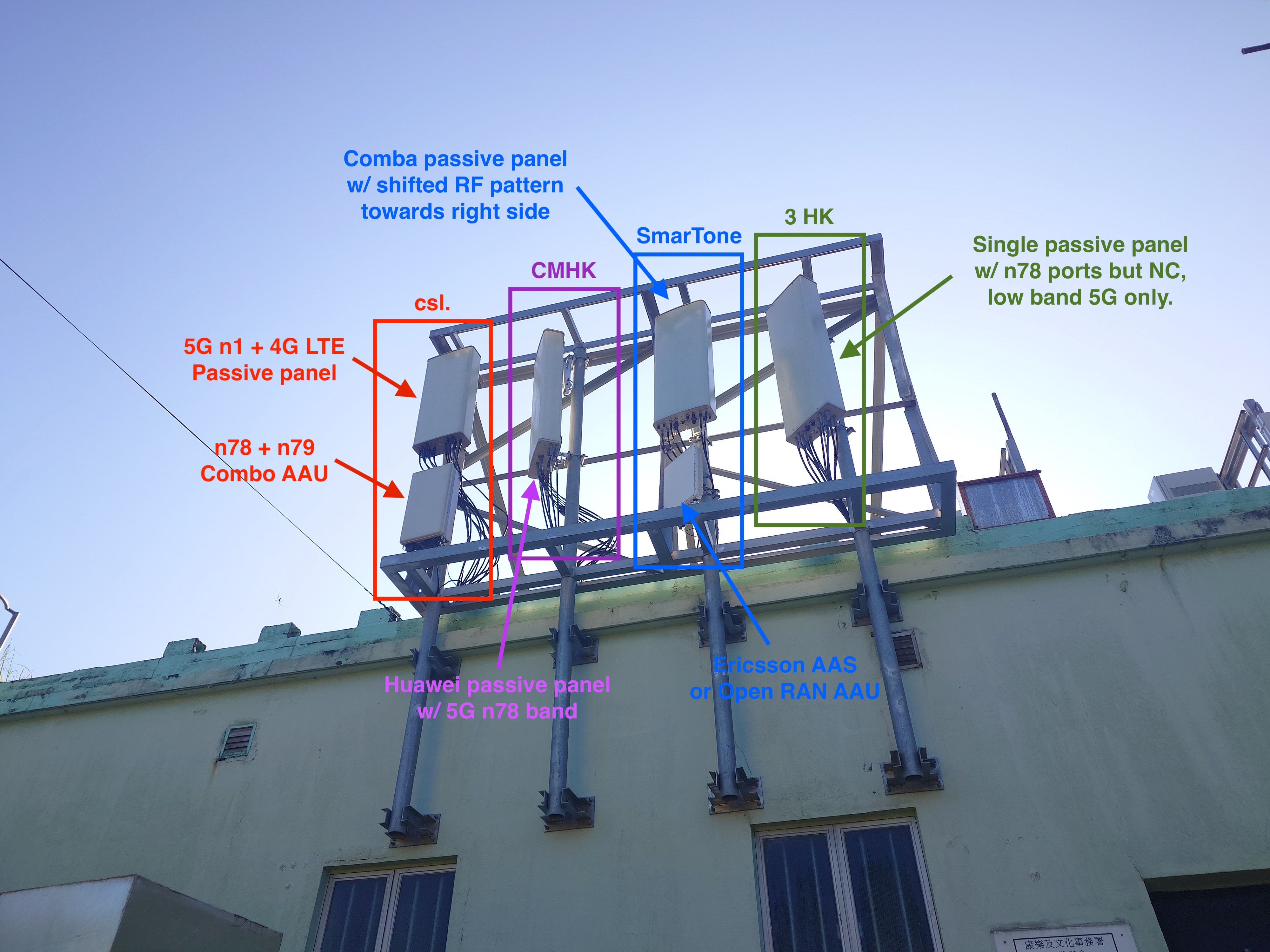
Annotated August site photograph. Hardware identifications reflect visible markings and diagnostic logs during the active build phase.
View full-size image (opens in a new tab)Supporting backhaul and power infrastructure were also evident. On-site equipment included dedicated electrical cutouts and fibre demarcation enclosures linked to HKT and HGC. While this verified physical connectivity, it did not prove diverse routing or multi-operator provisioning.
The empirical RF logs highlighted a clear operational issue: Tai Tam Reservoir Road gained virtually no improvement on bands n78 and n79. Across the sampled test points, the new site served the road basin almost exclusively via 2.1 GHz (band n1). While signal scattering along surrounding rock faces provided intermittent reception, handset telemetry confirmed the absence of a stable direct-path mid-band signal.
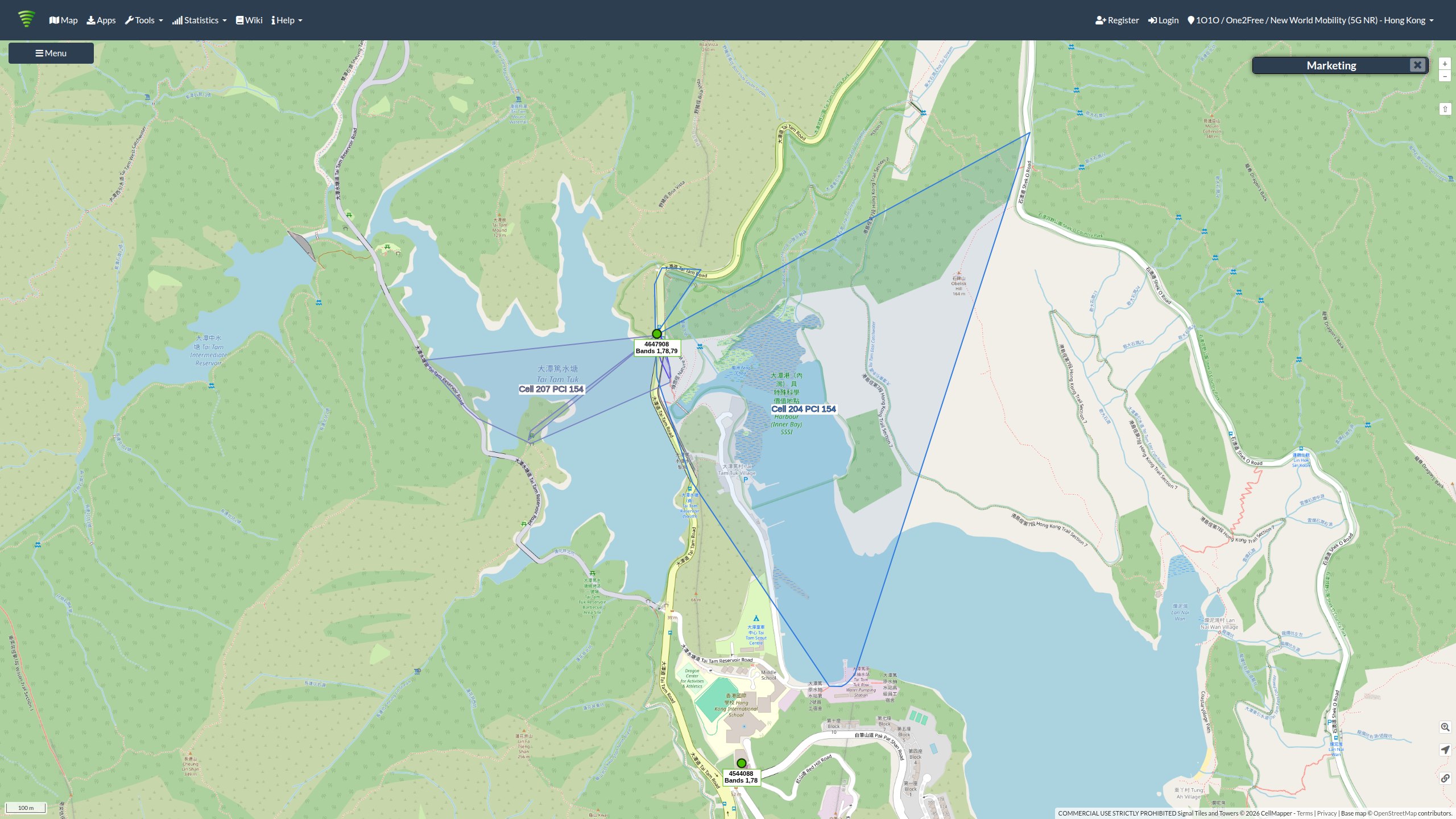
Empirical coverage track from the August site visit, showing recorded handset observations along sampled paths around the reservoir.
View full-size image (opens in a new tab)Correcting the antenna direction
My preliminary propagation model assumed the second sector pointed directly northwest toward the dam. On 12 August, closer inspection revealed that the physical antenna mounting was aligned significantly more eastward, closely tracking the path of Tai Tam Road (大潭道). I published an azimuth correction and updated the model. Realigning the simulated bore-sight confirmed a marked drop in predicted signal levels across the inner reservoir.
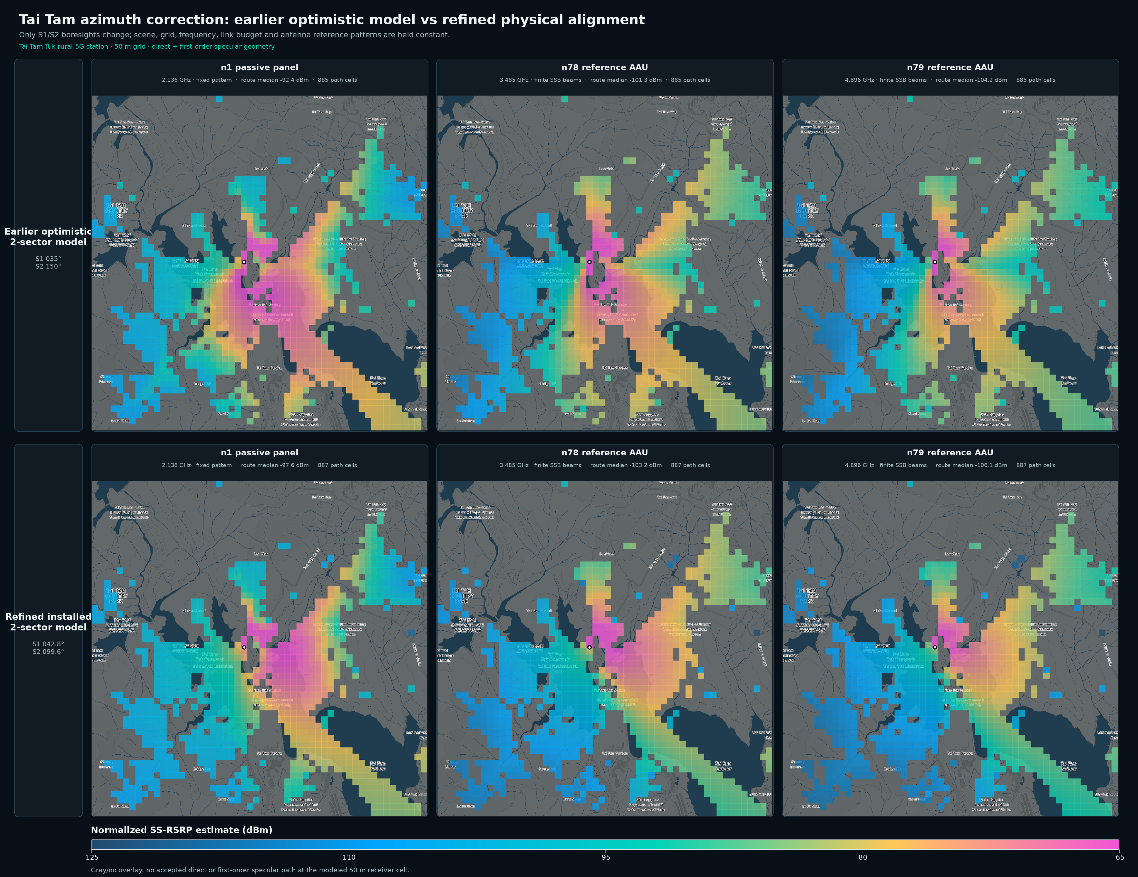
The 12 August azimuth comparison: optimistic alignment (top row) versus physically corrected alignment (bottom row).
View full-size image (opens in a new tab)The revised simulation incorporated manufacturer-typical AAU radiation envelopes, dynamic beam envelope approximations, and rough knife-edge diffraction parameters. Radiated power figures and down-tilt settings were estimated. While the revised output aligned closely with my drive and walk-test logs, empirical calibration does not turn a simulation into absolute truth. The full parameters can be inspected in the corrected two-sector interactive report.
What a third sector might change
Next, I modelled a hypothetical third sector oriented directly into the inner reservoir basin. The simulation demonstrated a pronounced signal boost across the shadowed trail segments. The details and ray-traced profiles are compiled in the three-sector interactive report.
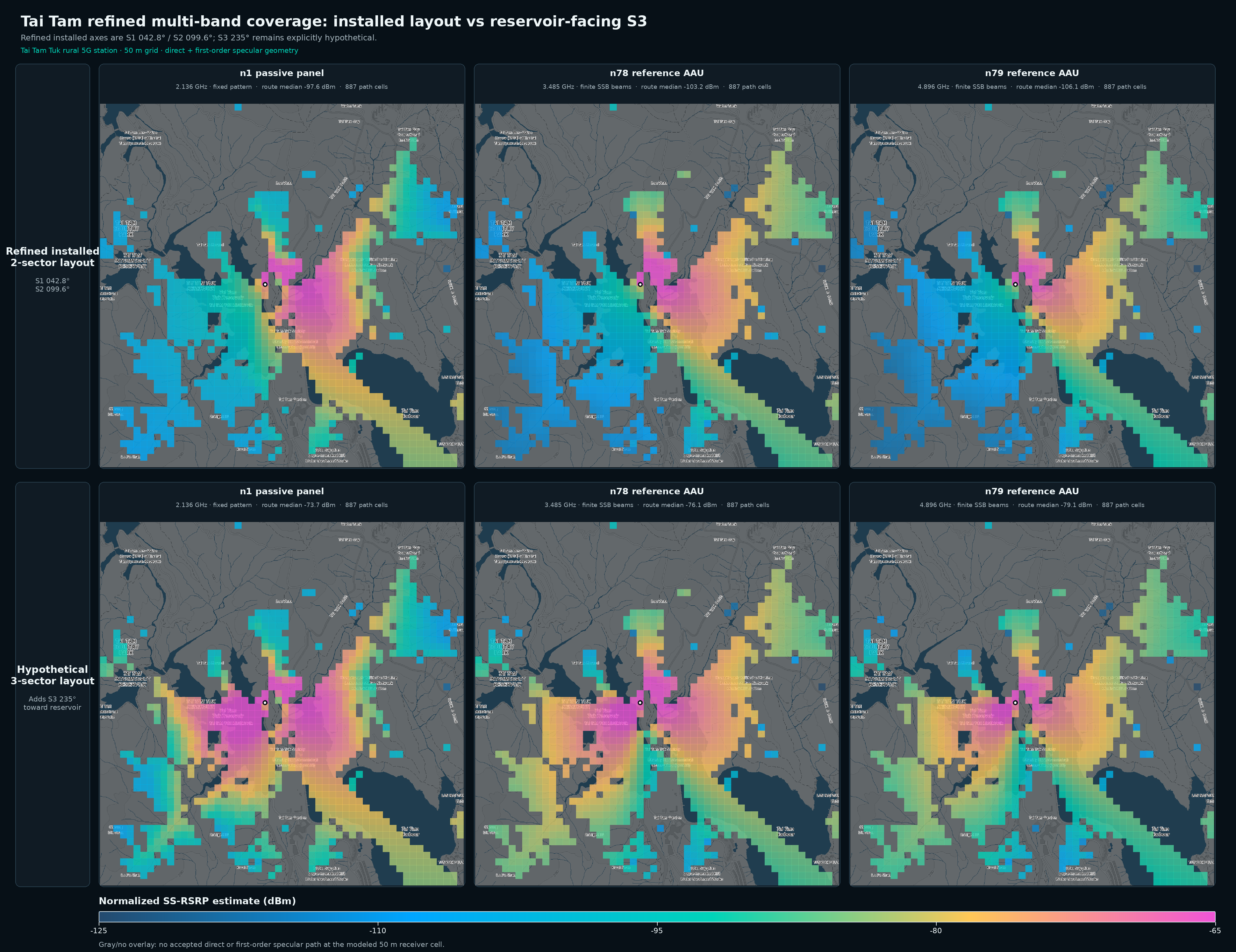
Simulated coverage across bands n1, n78, and n79 assuming a dedicated third sector facing the reservoir. This models a design alternative, not installed hardware.
View full-size image (opens in a new tab)A key distinction must be made regarding existing baseline service. In my 9 August update, I documented stable n78/n79 coverage within Tai Tam Tuk Village (大潭篤村) served by legacy macro sites, delivering downlink throughput near 400 Mbps. The design critique is not that the valley lacked connectivity altogether, but that the public investment in the new base station delivered negligible incremental performance to the unserved sections of the reservoir basin.
As noted in my 19 August follow-up, the rooftop location itself is structurally viable; clear line-of-sight to the road is available from multiple mounting points. The shortfall stems from sector layout: without a sector dedicated to that corridor, the available link budget is squandered. Because work was ongoing during my inspection, these findings reflect intermediate deployment conditions rather than formal operational acceptance testing.
Big Wave Bay, Hong Kong Island · 大浪灣
At Big Wave Bay, building a new site from scratch may not be the most effective intervention. My January inspection confirmed an active cellular installation mounted on structural steel atop the beachfront commercial building locally known as the Coke Store, with hardware profiles consistent with modern AAUs.
Identifying an operating installation does not automatically prove sufficient capacity or complete geographic coverage. The critical task is establishing where service degrades: along the beach perimeter, inside village alleyways, along the steep approach roads, or during peak weekend surf crowds when cell breathing and resource block exhaustion occur. Greenfield investment should only proceed if the existing mast cannot be upgraded or re-sectored.
Note that this refers to Big Wave Bay on Hong Kong Island, not the identically named bay on the Chi Ma Wan Peninsula of Lantau Island.
Tai Tam Upper Reservoir · 大潭上水塘
The proposed base station at the public toilet along Tai Tam Reservoir Road raises significant radio design concerns. While inspecting the site during its January reconstruction, I noted the steep terrain immediately to the west, which severely restricts line of sight into the Tai Tam Upper Reservoir basin.
Rebuilding a municipal facility provides an efficient window to install cable risers, structural footings, and electrical supplies. However, civil convenience cannot overcome fundamental terrain blockages. As of August, civil works were still underway, with no operational RF hardware present.
Planners should instead assess existing elevated infrastructure across Mount Butler (畢拿山), the AFCD Tai Tam Management Station, and Mount Parker (柏架山). Securing wayleaves, power extensions, and structural approvals on remote ridgelines is undeniably difficult, but their radio line of sight is far superior to a low-elevation public toilet. Existing csl coverage extending from Hong Kong Parkview (陽明山莊) and Mount Parker must form the performance baseline for any investment here.
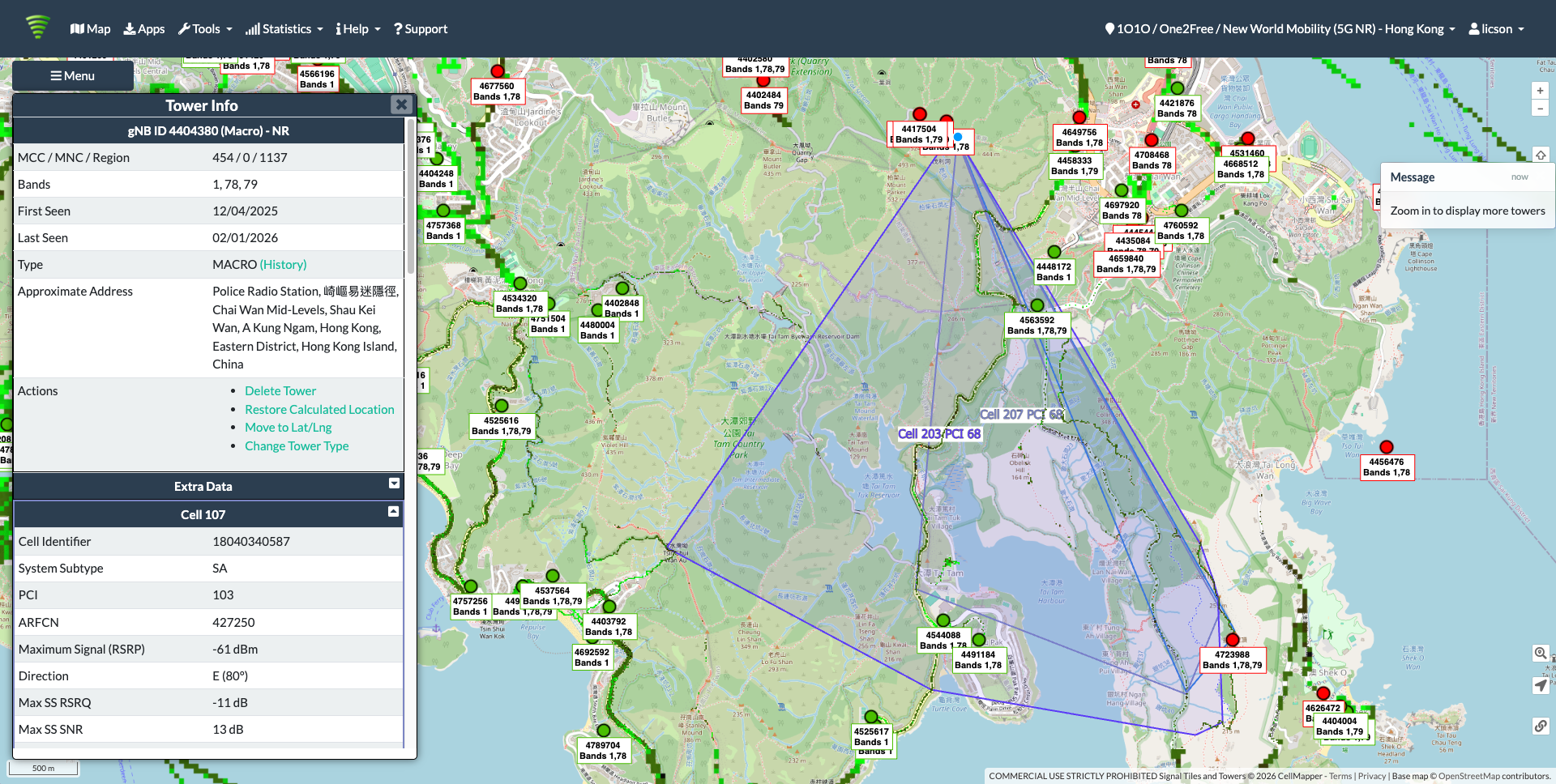
Mount Parker 5G coverage records referenced in the January review. Coverage boundaries reflect crowdsourced handset logs.
View full-size image (opens in a new tab)Tai Mei Tuk · 大美督
At Tai Mei Tuk, the primary limitation is the modest height of the proposed public toilet structure relative to the extensive surrounding terrain. I recommended evaluating an elevated mast installation on an adjacent ridge to achieve genuine regional coverage.
The coverage objectives extend far beyond the immediate parking apron: they encompass village settlements, watersports facilities to the southwest, and recreational trails ringing Plover Cove Reservoir (船灣淡水湖). My initial layout suggested a three- to five-sector deployment to address these distinct sectors independently.
The map below highlights a candidate ridge location. Identifying a topographically advantageous site does not resolve statutory zoning, land allocation, environmental reviews, or backhaul trenching. Those civil engineering constraints are formidable. Nevertheless, the elevated candidate and the low-elevation public toilet should be compared directly in terms of incremental population and trail area served per dollar spent.
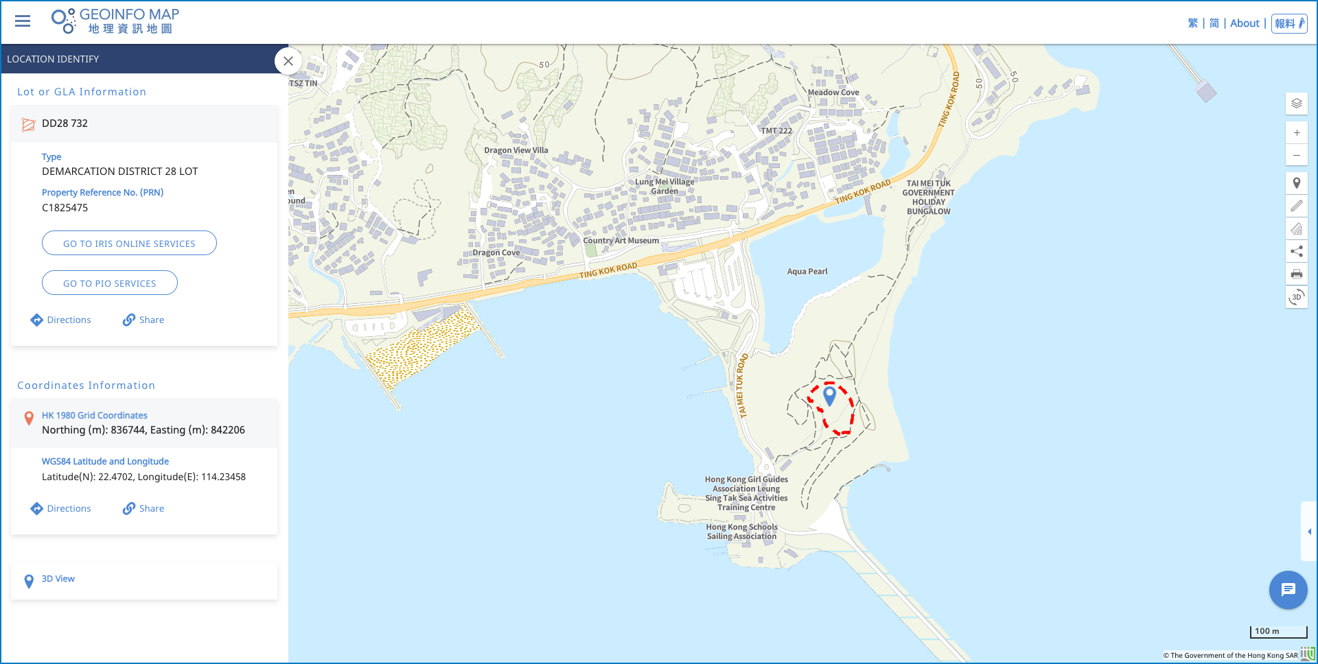
Candidate elevated location evaluated in January near Tai Mei Tuk. The marker represents an exploratory candidate, not an approved site.
View full-size image (opens in a new tab)Wong Yi Chau · 黃宜洲
Having stayed at the YMCA campsite on Wong Yi Chau, I found reception to be functional yet erratic. In January, I analyzed serving cells arriving across the water from Kau Sai Chau (滘西洲) and mainland sites around Tsam Chuk Wan (斬竹灣).
Evaluating surrounding macro cells is essential; Wong Yi Chau is not an RF desert. However, intermittent reception from a distant coastal station does not deliver reliable high-throughput service across the island. Handset data captured in this sector primarily reflected 4G anchors; they do not prove dependable n78 or n79 coverage. Verifying true mid-band performance will require dedicated walk testing.
I suggested evaluating a microcell installation on the elevated perimeter of the campsite’s activity grounds. This elevated vantage point provides direct line of sight over both the campsite and surrounding village houses, far outperforming the low-lying public toilet option. Realizing this design would require an infrastructure access agreement with the YMCA and an unobtrusive structural footprint compatible with camp operations.
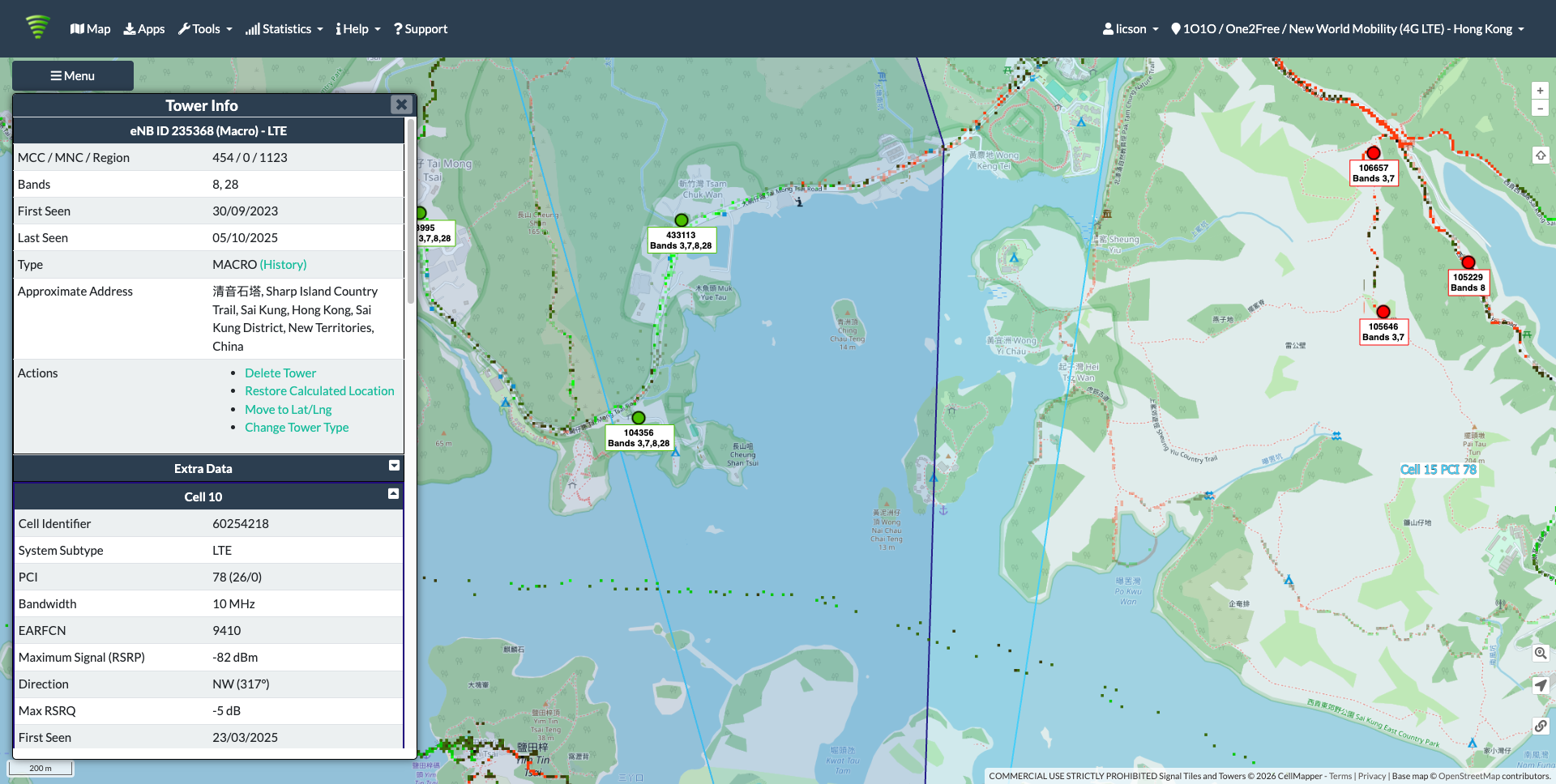
Historical 4G coverage log from Kau Sai Chau examined during the January review. It does not indicate comparable 5G footprint or performance.
View full-size image (opens in a new tab)Start with the places that need service
These nine sites reinforce a single engineering priority: define the specific communities, trails, and transit corridors that require coverage; establish what existing macro sites deliver; and deploy antenna configurations engineered to address the remaining gaps.
Public buildings provide convenient structural footings where land access is otherwise difficult to negotiate. But convenient rooftops and high hilltops are not interchangeable panaceas. Sound network design links structural constraints directly to RF propagation realities.
The process at Tai Tam underscores the necessity of empirical verification. Adjusting a modelled azimuth by a few dozen degrees completely altered predicted coverage, while field measurements in the village clarified that high-capacity coverage already existed nearby. Keeping those boundaries distinct—what was visually observed, what was mathematically inferred, and what remains unverified—is vital as public projects advance.
The standard for success is reliable connectivity where people actually need it. For publicly subsidized telecommunications infrastructure, that incremental value must be systematically proven, not merely assumed. Commissioning a base station is not the end of the project—it is where the real verification begins.
Sources and further reading
- Original January review and surrounding HKEPC discussion.
- My October 2025 Lamma observations and 7 August 2026 programme-progress note.
- OFCA’s scheme overview and frequently asked questions.
- Ericsson’s study of rural 5G coverage and capacity.
The August field notes, azimuth correction logs, and simulation models are linked at their respective sections. Field photography, spectrum plots, and coverage simulations are hosted on original object storage with full attribution and metadata intact.