The Hilltop Scarcity Illusion: Why Hong Kong's Rural Mobile Blackspots Are an Allocation Failure
An engineering and geospatial analysis of 39 hilltop station positions and 471 terrain paths across Hong Kong, showing that rural mobile blackspots stem from restricted access to existing radio structures rather than a physical shortage of summits.

Hikers in Hong Kong know the frustration well: you climb a prominent ridge in a country park, look across the valley, and see steel lattice towers and telecommunication radomes crowning the neighbouring peak. Yet on your phone, the signal drops from five bars of 5G to “No Service.”
For nearly a decade, the telecommunications regulator and mobile network operators have offered a consistent explanation: Hong Kong suffers from a severe physical shortage of hilltop radio sites. Steep terrain, strict statutory country-park protections, environmental visual impact rules, and aviation constraints supposedly leave little to no room for commercial cellular equipment.
That explanation has never been measured.
Hong Kong does not suffer from a scarcity of hilltops. It suffers from an administrative access and allocation failure: operators are kept off the steel towers, equipment rooms and power supplies that already stand on them.
Following my earlier analysis of rural 5G deployments, which evaluated nine subsidised base station builds from the ground up, I conducted a geospatial and radio propagation study of Hong Kong’s elevated infrastructure. Combining the Lands Department’s 5 m Digital Terrain Model (DTM) with official station records, site observations and crowdsourced coverage measurements, I evaluated 39 hilltop station positions across 471 terrain paths, generating 2,826 frequency-, height- and path-specific screening records.
The evidence is clear: the binding constraint on hilltop coverage is not a shortage of summits or structures. It is who may use them. Rural connectivity is held back by an administrative rationing regime that keeps public hilltop structures inside departmental silos while letting single operators hold exclusive sites on public summits.
The Scarcity Claim: Asserted, Never Measured
The regulatory cornerstone of hilltop radio policy in Hong Kong is the Office of the Communications Authority (OFCA) Guidance Note GN-8/2018, issued in July 2018. The document establishes a doctrine of physical scarcity:
“The supply of hilltop radio sites and associated facilities is very limited.”
Based on this premise, GN-8/2018 creates an administrative rationing scheme. It cites land constraints, environmental and aviation controls, remote access, and demand exceeding supply. It gives priority to government and defence users, while commercial mobile network operators (MNOs) seeking hilltop space must demonstrate strict necessity, public benefit, minimal space requirements and electromagnetic compatibility.
Yet OFCA has never published an empirical audit supporting its scarcity claim:
- No position-level inventory of occupied, reserved, or spare antenna mounting space across government masts has ever been published.
- No structural capacity register detailing wind-load margins or rack space in hilltop equipment shelters exists in the public domain.
- No register of rejected applications or the engineering reasons for refusal has ever been disclosed.
Where OFCA does record a constraint, it is site-specific: its country-park table notes space limitations at Cloudy Hill, Robin’s Nest and Pak Kung Au. That is exactly the kind of record a position-level audit should publish for every site.
Scarcity is asserted by administrative fiat, not measured through engineering analysis.
The Misleading Comfort of Aggregate Percentages
To deflect public criticism of persistent rural blackspots, official statements cite high coverage percentages. As of 13 May 2026, government reporting puts mobile network coverage at “around 80%” across country parks and “around 95%” along major hiking trails.
These numbers say little about whether a given subscriber has service on a given trail.
| Official Metric | Reported Level | Engineering Reality |
|---|---|---|
| Country-Park Coverage | ~80% | An aggregate across all networks. It is not each operator’s coverage, let alone each operator’s 5G coverage. A subscriber on one network can still walk into dead zones that the headline figure counts as covered. |
| Major Hiking Trails | ~95% | A trail-length denominator. It does not represent contiguous park area, and it conceals shadowed villages and broken route segments between covered stretches. |
| After the Rural 5G Programme | >90% of parks; >98% of major trails | An expected improvement, not an achieved result. It remains an aggregate, with the same blind spots. |
Aggregate numbers treat coverage as a binary territory-wide checkbox. Useful mobile coverage requires a working link, in both directions, along specific corridors and in specific settlements, verified per operator.
The Existing Asset Base: Summits Are Already Crowned
The central irony of Hong Kong’s hilltop radio policy is that the territory’s ridgelines are far from untouched wilderness. Radio infrastructure stands on most major hills. The 39 positions assessed in this study include 13 government radio stations, 13 broadcast stations, 9 mobile sites listed by OFCA and 2 HKT-owned stations:
- Broadcast stations: Digital terrestrial television and FM transmitting stations crown the major regional summits, including Castle Peak, Temple Hill, Kowloon Peak, Golden Hill, Cloudy Hill, Mount Gough, and Mount Nicholson.
- Government radio stations: Police radio stations on Mount Davis and Mount Parker, three government positions on Mount Butler, the Victoria Peak VHF station, the ICAC radio station on Mount Kellett, and government stations at Brick Hill, Ling Kok Shan, Tai Shek Mo and Kai Kung Shan.
- Aviation and weather installations: Civil Aviation Department (CAD) radar beside Mount Parker, weather radar on Tai Mo Shan, and an active summit installation on Nei Lak Shan.
- Listed mobile sites and lookouts: Mobile locations that OFCA lists in the country parks, such as Shek Uk Shan, Robin’s Nest and Pak Kung Au, and the fire lookout at Wong Chuk Yeung.
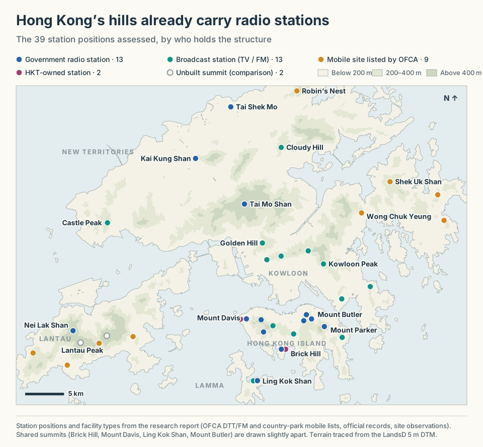
The existing asset base. Government, broadcast and listed mobile stations already stand on most of Hong Kong’s major hills; what is scarce is access to them.
View full-size image (opens in a new tab)These facilities have already solved the hardest problems in remote infrastructure: land allocation, access, a standing structure and a power supply. Their spare mounting space, power and backhaul headroom have never been published, which is exactly what a public register should fix.
The infrastructure exists. What is missing is a regulatory mechanism allowing commercial mobile operators to share it.
The Working Precedents: Shek Uk Shan and Mount Parker
Policymakers often argue that co-locating commercial cellular equipment onto government radio posts is operationally impractical due to security, structural load, or electromagnetic interference (EMI).
Existing installations disprove this objection:
- Shek Uk Shan (石屋山 · Sai Kung): Rising to 481 m HKPD in the Sai Kung country parks, Shek Uk Shan is the benchmark for multi-operator infrastructure sharing. Mobile antennas are mounted on the existing radio masts, and OFCA’s registry lists all four operator groups (HKT, 3 Hong Kong, China Mobile Hong Kong and SmarTone) at the site. A single elevated summit compound serves the Sai Kung hills and the surrounding waters without requiring a single square metre of new hilltop land.
- Mount Parker (柏架山 · Hong Kong Island): Near the 532 m summit, the police radio station on Mount Parker carries a full commercial HKT base station: LTE on four bands and 5G on three, from 700 MHz to 4.9 GHz, beside police radio and within 320 m of CAD’s two radar stations. Crowdsourced CellMapper measurements show its southern 5G sectors reaching up to 6.7 km, across Tai Tam Gap, Tai Tam Harbour, the Dragon’s Back ridge, Shek O Peak and Red Hill: country-park trails that a lower site could not reach.
Mount Parker proves that a full commercial deployment can operate on a police communications facility beside aviation radar. Structural loading, power and electromagnetic compatibility are solved in practice on this hill.
Yet Mount Parker also reveals the dark side of administrative discretion: no other operator has been identified at the station. A government radio station already shown to host a full commercial deployment serves one operator’s customers. An equal-access offer would extend the same trail coverage to subscribers of SmarTone, China Mobile Hong Kong and 3 Hong Kong.
Sharing works. But without an open-access mandate, it degenerates into private preference.
Natural Experiments on the Same Summit: Position Beats Elevation
To quantify the engineering impact of administrative access, I screened line-of-sight terrain profiles on the Lands Department DTM across Hong Kong’s most contested peaks. Pairing stations on the same summit yields compelling natural experiments.
1. Brick Hill (Nam Long Shan · 南朗山): 28 Metres, Identical Terrain
A striking example of administrative distortion sits atop Brick Hill (284 m HKPD), overlooking Ocean Park, Aberdeen, and the East Lamma Channel.
The summit hosts two separate radio stations just 28 metres apart:
- An exclusive HKT station running LTE and 5G.
- A government radio mast, closed to commercial operators.
I screened both structures against 53 receiver points: 35 sampled every 100 metres along Black’s Link, 12 along the western approach to Violet Hill, four on Lamma Island, and two named destinations (Wah Fu and Repulse Bay).
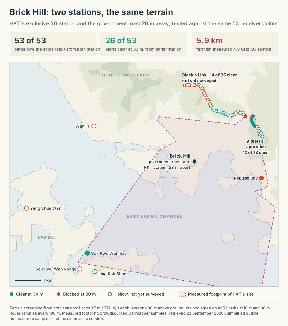
The Brick Hill natural experiment. Both stations give the same result on all 53 paths; measurements of HKT’s site show that this geometry delivers service on the Violet Hill approach and across the channel to Lamma.
View full-size image (opens in a new tab)The outcome is stark: the HKT station and the government mast give the same line-of-sight result on 53 out of 53 paths at an antenna height of 10 m and at 30 m, and on 52 of 53 at 50 m.
Neither is a perfect site. At 30 m, each clears 14 of the 35 Black’s Link samples, 10 of the 12 on the Violet Hill approach, and 2 of the 4 Lamma points. But they clear exactly the same ones.
Crowdsourced measurements of HKT’s own site confirm that this geometry delivers service: 6 of the 12 Violet Hill samples fall inside its measured footprint, and across the East Lamma Channel a 4.9 GHz 5G sample was logged at Sok Kwu Wan bay, 5.9 km from the station. Black’s Link has not yet been surveyed; the absence of measured samples there is not evidence of absent coverage.
HKT’s exclusive site secures no geometric advantage over the public mast 28 metres away. The only difference is who may use it: HKT holds its site exclusively, while the government mast beside it stays closed to the other three operators, who reach the same southern slopes only by incidental overshoot from urban sites.
Opening the government mast would let every operator reproduce HKT’s southern reach without new land. The capacity exists on Brick Hill. It is simply locked behind a regulatory gate.
2. Mount Butler (畢拿山): Micro-Siting on a Single Ridge
Conventional planning often assumes that any tower on a named mountain will perform identically. Mount Butler demonstrates why micro-siting along a ridgeline matters far more than gross summit height.
Mount Butler carries three government radio positions, 258 to 421 metres apart on the ridge below its 436 m summit:
- Position #1 (North Mast): On the northern crest (22.27892° N, 114.20196° E).
- Position #2 (West Radomes): On the western spur (22.27660° N, 114.20172° E).
- Position #3 (East Vantage Point): On the eastern brow (22.27864° N, 114.20517° E).
Testing all three positions against 69 receiver points sampled every 100 metres along Mount Parker Road and Sir Cecil’s Ride reveals extreme divergence:
| Mount Butler Position | Ground Level (DTM) | Trail Samples Clear at 30 m | Clearance Percentage |
|---|---|---|---|
| Position #1 (North Mast) | 293 m HKPD | 2 of 69 | 2.9% |
| Position #2 (West Radomes) | 314 m HKPD | 1 of 69 | 1.4% |
| Position #3 (East Vantage Point) | 308 m HKPD | 21 of 69 | 30.4% |
Although all three positions sit within a few hundred metres of each other and within 21 metres of the same elevation, Position #3 clears ten times as many trail samples as Position #1, and twenty times as many as Position #2.
Intervening spurs and slope shoulders blind Positions #1 and #2 to the trails below. If OFCA were to ration access by offering Position #1 while reserving Position #3, a commercial deployment would fail despite sitting “on Mount Butler.” Siting is a game of angles, not summit benchmarks.
3. Wong Chuk Yeung (黃竹洋 · Sai Kung): The Lookout Trap
In the Sai Kung hills, the settlement of Wong Chuk Yeung presents the plainest picture of the problem.
Two operators, China Mobile Hong Kong and SmarTone, mount their antennas on a low fire lookout. Immediately beside the lookout stands a taller government communications mast, closed to commercial co-location.
The terrain screening shows that the trap is one of access, not of height. From the station, Pyramid Hill is clear at every antenna height tested (+1.9 m at 10 m, +2.0 m at 50 m), and Sham Chung is blocked at every height (−39.8 m at 10 m, −34.3 m at 50 m). Twenty more metres of steel would change neither result. The question the site raises is why operators sit on the lower structure at all, while the taller government mast, at its own position, stays closed to them.
4. Mount Davis (摩星嶺): Two Facilities, Different Reach
At the western tip of Hong Kong Island, Mount Davis (269 m HKPD) looks over Kennedy Town, the western harbour approach and the West Lamma Channel.
Like Brick Hill, Mount Davis hosts two separate facilities: an HKT microwave station and a police radio station, 252 metres apart. Unlike Brick Hill, they do not see the same terrain:
- From the police radio station, Kennedy Town is clear with a 30 m antenna (+3.9 m clearance). From the HKT station it is blocked at 30 m (−17.8 m) and still blocked at 50 m (−2.5 m).
- Towards the International Commerce Centre (ICC), 4.6 km across the harbour, the police radio station clears all six elevated receiver heights tested with only a 10 m antenna; the HKT station clears none at that height. A separate screen of 587 building footprints along the path checks these rays against rooftops.
- Both clear the West Lamma Channel, High West and Lung Fu Shan; neither reaches Sandy Bay at 30 m.
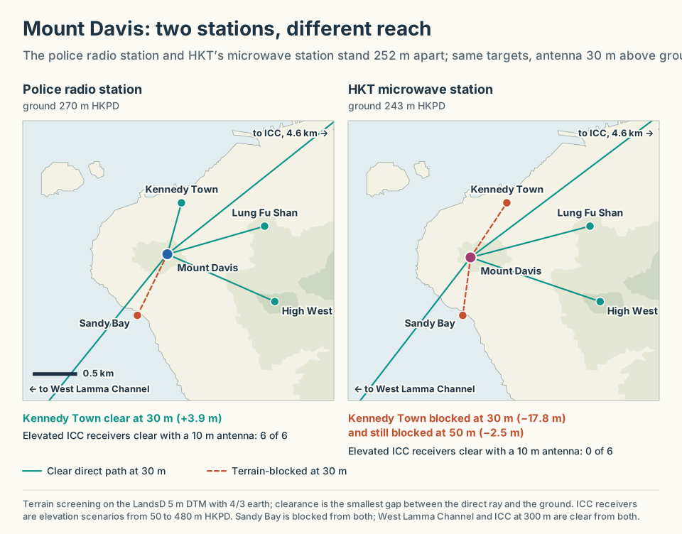
Mount Davis: two structures 252 m apart with different reach. The police radio station clears Kennedy Town at 30 m; no height tested at the HKT station does.
View full-size image (opens in a new tab)No mounting height tested at the HKT station reaches what the police radio station reaches at 30 m. The right existing structure is worth more than extra height on the wrong one, and on Mount Davis the better structure is the government one.
5. The New Territories Country-Park Deficit
While Hong Kong Island has a dense cluster of existing radio sites, the New Territories, where most of the country parks lie, has far fewer. The New Territories and Sai Kung hold 14 of AFCD’s 25 designated country parks, against 6 on Hong Kong Island. Yet only 3 of the 12 hills assessed there carry a government radio station, against 6 of 9 on Hong Kong Island. Where the choice of existing structures is narrowest, each one matters more.
Two government stations stand out:
- Tai Shek Mo / Crest Hill (大石磨 · 183 m HKPD): On Government Land Allocation GLA-DN 128 near the boundary. At 30 m it clears Ma Tso Lung, Long Valley, Pak Tai To Yan and the Robin’s Nest summit; Lau Shui Heung Reservoir is shadowed.
- Kai Kung Shan (雞公山 · 290 m HKPD at the station): On the western Kai Kung Leng ridge above Kam Tin and Pat Heung. At 30 m it clears Kai Kung Leng, Kwun Yam Shan above Lam Tsuen, the Tai Mo Shan summit and Ho Pui Reservoir; Kap Lung Ancient Trail and Tai To Yan are shadowed.
Opening Tai Shek Mo and Kai Kung Shan to multi-operator equipment substantially reduces the need for new summits in the northern and western country parks. Where they are shadowed, local infill does the rest.
Radio Physics: Why Lofty Summits Are Cellular Traps
When non-engineers look at a topographic map of Hong Kong, their immediate instinct is to target the highest peaks: Tai Mo Shan (957 m), Lantau Peak (934 m), or Sunset Peak (869 m).
In cellular network design, this instinct is fundamentally mistaken. Lofty summits are notorious engineering traps.
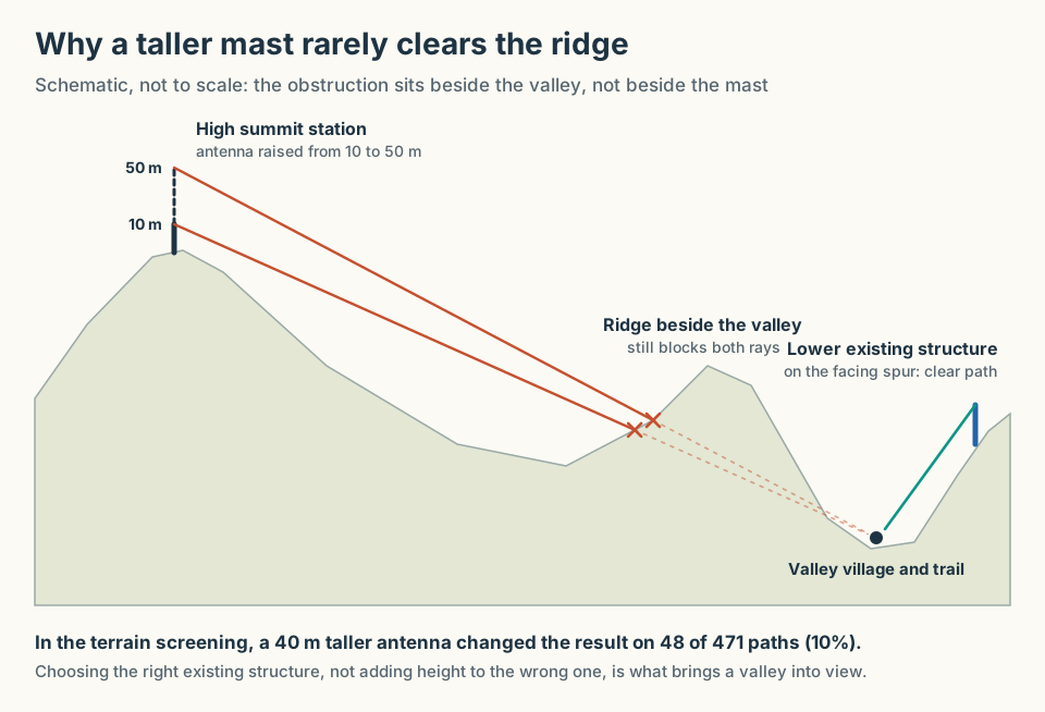
Why a taller mast rarely clears the ridge. The obstruction sits beside the valley, where 40 m of extra height at the far summit barely moves the ray.
View full-size image (opens in a new tab)1. The Height Paradox: 10 m vs. 50 m Masts
A central parameter in my study was antenna mounting height. Across all 471 screened paths, I calculated geometric and Fresnel zone clearance at 10 m, 30 m, and 50 m above ground level.
The findings dismantle the assumption that taller masts cure topographic obstruction:
- On 423 out of 471 paths (89.8%), changing antenna height from 10 m to 50 m had no effect on line-of-sight status.
- Raising the mast turned a blocked path into a clear one on only 48 paths (10.2%).
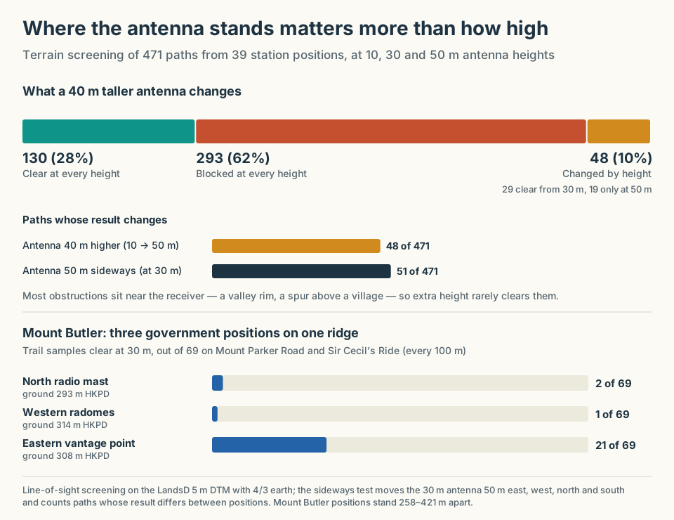
Where the antenna stands matters more than how high. A 50 m sideways move changes at least as many results as a 40 m lift, and Mount Butler’s best position clears ten times as many trail samples as its worst.
View full-size image (opens in a new tab)Most obstructions sit near the receiving end (a valley rim, a spur above a village) and do not move when the antenna rises. Height pays only where the obstruction is in the foreground. Moving the 30 m antenna just 50 metres east, west, north or south changes the result on 51 paths, about as many as the 40 m lift. If a site lacks the proper look-angle into a valley floor, building a taller tower is an expensive exercise in futility. Horizontal position, meaning which existing structure, matters at least as much as height, and usually more.
2. The Downtilt and Near-Field Ground Strike Dilemma
Placing cellular base stations atop Hong Kong’s highest peaks introduces severe vertical geometry problems.
To illuminate a hiking trail or a village near sea level from the summit of Tai Mo Shan (957 m) at a distance of 3 km, an antenna array requires a mechanical and electrical down-tilt of 15 to 18 degrees. At 500 m above the target, a 6° tilt puts the centre of the main beam 4.8 km away; even 10° lands it 2.8 km away.
At such steep angles, two problems emerge:
- Near-Field Ground Strike: The bottom half of the antenna’s main radiation lobe strikes the mountain shoulder just in front of the tower, scattering RF energy into unpopulated rock faces and degrading the beam pattern.
- The Overshoot Void: If down-tilt is reduced to avoid ground strike (e.g., set to 4 to 6 degrees), the main beam overshoots the populated valley floor, projecting energy over the hills, out to sea and into distant urban cells, while leaving the valley in the antenna’s vertical nulls.
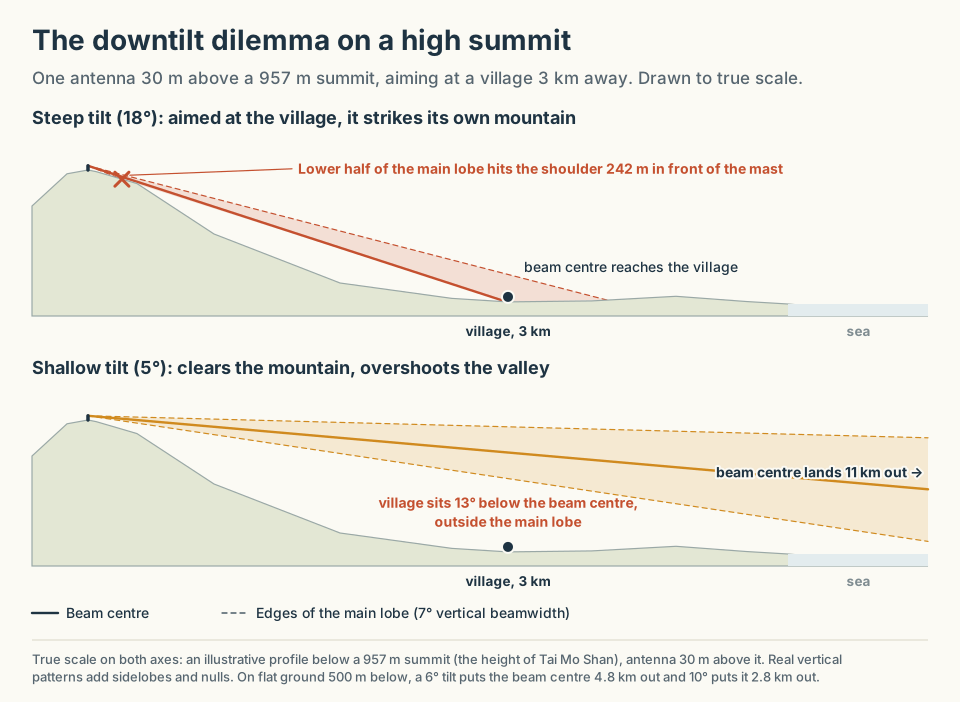
The downtilt dilemma. Tilted steeply enough to reach the village, the beam hits its own mountain; tilted shallowly enough to clear it, the beam passes over the valley.
View full-size image (opens in a new tab)A summit station serving distant coastal corridors with modest downtilt cannot also illuminate the village directly beneath its ridge. Peaks above 700 m HKPD add persistent cloud, high humidity, typhoon wind loading and, in cold spells, rime ice on antennas and radomes, each adding cost and outage risk.
Mid-elevation ridges, roughly 200 to 550 m HKPD, such as Brick Hill (284 m), Shek Uk Shan (481 m) and Mount Parker (532 m), provide the sweet spot: useful look-angles into target corridors without destructive ground strike or severe mountain weather.
3. The Uplink Asymmetry: The “Vanity Bar” Illusion
The most fundamental limitation in remote cellular engineering is the difference between what the base station can transmit and what the user’s phone can:
| Transmitter | Maximum power |
|---|---|
| Base station (per carrier) | 40 W (+46 dBm) |
| Handset (3GPP Power Class 3) | 0.2 W (+23 dBm) |
The raw 23 dB gap overstates the deficit: the base station also has high receive antenna gain, diversity reception and processing gain on its side. But on long, high paths the handset uplink, not the base station’s downlink, is the binding constraint.
The base station enjoys mains power, high antenna array gain (+18 to +24 dBi), and beamforming. The hiker’s smartphone is a battery-constrained device with a small internal antenna and a maximum transmit power of about 200 milliwatts.
When a base station is perched too high or too far away:
- The smartphone easily detects the tower’s high-power reference signal.
- The phone displays “Four Bars of 5G” on its status screen.
- The user attempts to send an emergency message or load a map.
- The smartphone’s 200 mW return transmission is swallowed by path loss, tree canopy absorption (10–20 dB), and environmental clutter.
- The base station never receives the request; the connection times out.
A high-elevation site that achieves line-of-sight on paper is of little use if the uplink cannot close. Real rural engineering requires siting stations close enough to target corridors that a handheld device can reliably reach them. Such positions already exist on intermediate government structures; the task is to allocate them, not to find more summits.
4. Spectrum Band Roles: 700 MHz vs. 3.5 GHz
A shared hilltop site must deploy spectrum bands according to their distinct propagation behaviour:
| Low band: 700 / 900 MHz (bands 28 / 8) | Mid band: 3.5 / 4.9 GHz (bands n78 / n79) | |
|---|---|---|
| Free-space loss at 5 km | About 103 dB (700 MHz) | About 117 dB (3.5 GHz), plus heavy canopy attenuation |
| Role | Continuous safety lifeline, voice fallback, broad geographic umbrella | High-capacity coverage along clear corridors and busy hubs (e.g., Pak Tam Chung, dam crests) |
| Limitation | Narrow bandwidth (10–20 MHz); easily congested by distant users | Needs a clean, direct line of sight; degrades sharply across shadowed terrain |
Mid-band on a hill is not wasted where the path is clear: HKT’s Brick Hill site has been logged on 4.9 GHz 5G 5.9 km away on Lamma. But mid-band energy does not bend into shadowed valleys. The primary mission of shared hilltop infrastructure is a robust, multi-operator 700/800/900 MHz low-band umbrella, supplemented by 1.8/2.1 GHz and mid-band sectors aimed along verified line-of-sight corridors.
The Policy Remedy: A Mandated Open-Access Radio Policy
Hong Kong cannot solve its rural connectivity deficit by building new low-level base stations one village at a time while the valleys beside them stay shadowed. Nor can it wait for operators to negotiate ad-hoc leases, one at a time, across fragmented government departments.
HKSARG and OFCA must retire the rationing philosophy of GN-8/2018 and replace it with a Mandated Open-Access Radio Infrastructure Policy.
This framework rests on four concrete, enforceable pillars:
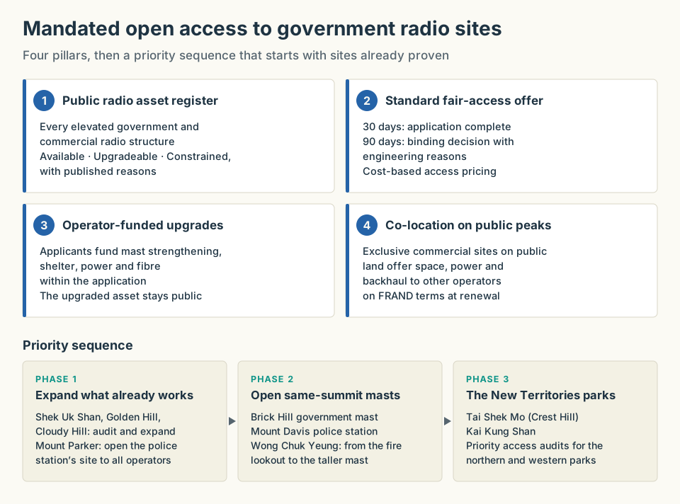
The proposed regulatory framework: a public register, a standard offer with binding deadlines, operator-funded upgrades and co-location conditions, rolled out from the sites already proven.
View full-size image (opens in a new tab)Pillar 1: A Transparent Public Radio Asset Register
OFCA must publish and maintain an authoritative, publicly accessible register of all elevated radio structures across Hong Kong, classifying every site into three clear operational tiers:
- Available: Structures with immediate spare mounting space, shelter rack space, and electrical capacity.
- Upgradeable: Structures that can accommodate commercial cellular equipment subject to operator-funded mast strengthening, cabinet expansion, or power upgrades.
- Constrained: Sites strictly limited by active national security, defence, or critical aviation radar geometry (with published engineering justifications).
Pillar 2: The Standard Fair-Access Offer
Replace opaque, discretionary inter-departmental referrals with a binding statutory application workflow:
- 30-Day Receipt: Formal acknowledgement of engineering completeness.
- 90-Day Binding Determination: Mandatory approval or reasoned engineering refusal. Rejections must cite specific structural, thermal, or radio-frequency interference calculations, not vague “land constraints.”
- Cost-Oriented Access Pricing: Rental rates pegged to actual facility maintenance and administration costs, eliminating speculative site markups on public land.
Pillar 3: Operator-Funded Upgrade Gates
Under current rules, if a government mast lacks the structural reserve to hold an additional 5G panel array, the application is simply rejected.
Under the Open-Access policy, commercial operators must be legally permitted to fund and execute the required civil upgrades within the application process:
- Replacing ageing steel lattice masts with higher-capacity structures.
- Expanding equipment rooms and DC battery plants.
- Underwriting optical fibre trenching and power cable reinforcement along access tracks.
The upgraded civil asset remains government property, while the funding operators receive long-term co-location rights. Public infrastructure is modernised using private capital.
Pillar 4: Structural Co-Location Mandates on Public Peaks
Where commercial operators currently hold private, exclusive compounds on public hilltops, as HKT does at Brick Hill and Mount Davis, the government must condition lease renewals on mandatory structural co-location.
Single-tenant commercial walled gardens on public summits must be phased out. If a private operator runs a base station on public land, it must be obligated to offer antenna space, power, and backhaul hand-offs to rival licensed operators on fair, reasonable, and non-discriminatory (FRAND) terms.
Priority Implementation Sequence
A pilot rollout should immediately target the lowest-hanging, highest-impact infrastructure assets:
- Expand what already works.
- Shek Uk Shan, Golden Hill and Cloudy Hill: Audit and expand the existing multi-operator infrastructure.
- Mount Parker: Open the police radio station’s commercial site to all operators.
- Open same-summit government masts.
- Brick Hill: Mount commercial antennas on the government mast to match HKT’s footprint.
- Mount Davis: Open the police radio station to commercial co-location.
- Wong Chuk Yeung: Move operators from the low fire lookout to the adjacent taller mast.
- Open the New Territories country-park belt.
- Tai Shek Mo (Crest Hill): Open the government station to multi-operator equipment for the northern parks.
- Kai Kung Shan: Open the government station for the western New Territories trails.
Siting Is Policy
In mobile telecommunications, physical geography is the ultimate arbiter. You cannot negotiate with a 300-metre granite ridge, and you cannot violate the Friis transmission equation.
Yet for eight years, Hong Kong has treated an administrative failure as a geographical constraint. We have accepted the narrative that hilltops are scarce, that country parks are inherently unserviceable, and that patchy, single-carrier coverage is the best a world-class digital metropolis can achieve.
The empirical data proves otherwise. The summits are already built on. The structures, access and power are already there.
The blackspots across Hong Kong’s country parks are not the fault of the mountains. They are the direct, predictable outcome of a regulatory framework that rations public assets instead of coordinating them. By instituting a mandated open-access policy for government radio infrastructure, OFCA can modernise rural connectivity, introduce genuine network competition, and ensure that when a hiker dials for help from a ridgeline, the network is actually there to answer.
Methodology, Data & Reproduction
- Primary Research Report: The full illustrated research report, including the per-site feasibility register for all 39 positions, illustrative diagrams and 43 terrain figures, underlies every number in this article.
- Spatial Data Sources: The 5 m Digital Terrain Model, Place Name dataset, road centrelines and building footprints from the Lands Department, via the Hong Kong Common Spatial Data Infrastructure (CSDI) Portal; country-park attractions from AFCD.
- Terrain Screening: Direct-ray screening along each path on the 5 m DTM with a 4/3 effective-Earth curvature model, testing geometric line of sight and 60% first Fresnel zone clearance at 700 MHz and 3,500 MHz, for antennas 10, 30 and 50 m above ground, with a ±50 m position-sensitivity test: 2,826 records across 471 paths.
- Field Evidence: Crowdsourced CellMapper measurements (retrieved 23 September 2026) for HKT’s sites at Mount Parker and Brick Hill, read as envelopes of observed samples rather than continuous coverage; site observations from my Rural 5G field review.